Home / Civil Engineering / Elements of Remote Sensing :: Section 1

Civil Engineering :: Elements of Remote Sensing

  1.  

    Which one of the following residual biases involves the GPS accuracy ?

  2. A.

    Satellite dependent baises due to uncertainty in the orbital parameters of the satellite.

    B.

    Receiver-depandent biases due to clock stability with line

    C.
    Signal propagation baises due to the sphere and troposphere propogation.
    D.

    All the above

    View Answer

    Workspace

    Discuss Discuss in Forum


  3. Pick up the correct definition from the following with response to GIS.

  4. A.

    Common boundry between two areas of a locality is known as adjacency.

    B.

    The area features which are wholly contained within another area feature, is known so containment.

    C.

    The geometric property which describes the linkage between line features is defined as connectivity.

    D.
    All of these.

    View Answer

    Workspace

    Discuss Discuss in Forum


  5. Which one of the following errors is produced by platform characteristics of the sensor ?

  6. A.

    altitude variation

    B.

    altitude

    C.

    orbit drift

    D.

    All of these

    View Answer

    Workspace

    Discuss Discuss in Forum


  7. The coherence length over which there is a strong relationship between amplitudes is;

  8. A.

    directly proportional to the bandwidth

    B.

    inversely proportional to the bandwidth

    C.

    the square of the bandwidth

    D.

    none of these

    View Answer

    Workspace

    Discuss Discuss in Forum


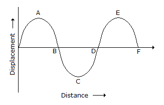
  9. in the given figure the phase of

  10. A.

    crest A is π/2

    B.

    B crossing is π

    C.
    trough C is 3 π/2
    D.

    All of these


  11. If 0 is the angle of scan measured from the nadir, the ground distance swept by the sensor IFOV is proportional to :

  12. A.

    sin2θ

    B.
    cos2θ
    C.

    sec2θ

    D.
    tan2θ

    View Answer

    Workspace

    Discuss Discuss in Forum


  13. Which one of the following statements is correct regarding the GPS satellites ?

  14. A.

    The nominal altitude is about 20, 200 km

    B.

    The inclination of axis satellite is 55°

    C.

    The satellite transmits two L band signals (L1 with 1575.42 MHz and L2 with 1276.6 MHz)

    D.

    All of these

    View Answer

    Workspace

    Discuss Discuss in Forum


  15.  

    Pick up the correct statement from the following:

  16. A.

    Indian space effort started in 1962 with the establishment of a rocket.

    B.

    Development of space (DOS) was established by the Government of India in 1972

    C.

    Indian Space Research Organisation (ISRO) is responsible for the space technology and its application to various activities.

    D.

    All of these

    View Answer

    Workspace

    Discuss Discuss in Forum


  17. Rayleigh's criteria for a rough surface is: (where letters carry their usual meanings).

  18. A.
    h > λ/Δ cos θ
    B.
    h > λ/Δ cos θ
    C.

    h > λ/8 cos θ

    D.

    h < λ/8 cos θ

    View Answer

    Workspace

    Discuss Discuss in Forum


  19.  

    Pick up the correct statement from the following :

  20. A.

    The distance between two successive crests or troughs of a wave, is called, the wave length

    B.

    The wave length is measured in metres and a fraction of a metre

    C.

    The wave length is generally denoted by λ

    D.

    The length of the crest from the mid point, is called amplitude

    E.

    All of these

    View Answer

    Workspace

    Discuss Discuss in Forum